On Sunday May 4th 2014 we had the opportunity to do some trail recon between Carlton Peak and Lutsen and conditions were almost identical to what we saw this same weekend last year, so we will almost verbatim repeat what we said about the trail last year in a post similar to this.  Note that last year on race day there was NO SNOW, this years long term forecast looks to be a little cooler leading up to the race so we may not be as lucky this year – that being said, much of the snow is going to melt regardless.

Driving up the North Shore on Highway 61, the sides of the road were snow-free and things looked promising. Trail conditions ranged from dry runnable trail to shoe-sucking mud, to deep standing slushy water and snow ranging in depth from 2 or 3 inches up to 3 feet in places. From what we have seen the forecast is not calling for very warm temps over the next two weeks so we suggest that you come prepared race day for sloppy trails and some patches of lingering snow and count on having wet feet (the kind where even if you change socks, your feet will just get wet again a few minutes later). You are welcome to email us questions about the course but your guess is as good as ours on what race day conditions will be like – our advice is to come prepared for any and all conditions. We will have an up to date report on the trails after we mark on Friday at the very informal and non-mandatory pre-race meeting on Friday night at 7PM (after packet pickup.) Before any ‘newbies’ panic, remember, this is trail-running, if we wanted the variable of imperfect running surface conditions taken out of the equation, we would sign up for road races only… take it as it comes, do what you can, have fun, run wild, be free, Rocksteady!

Questions we have received recently, answered below:

Question: Will the race be canceled if there is still snow? Answer: No, we are trail runners.

Question: Will the course be modified if there is snow and mud? Answer: Not likely.

Question: Do you know what the trail will be like on race day? Answer: We can guess, but so can you.


SHT3-5-4-14

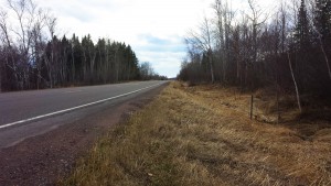
Ditches on the side of Highway 61

SHT1-5-3-14

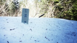
Deep Snow – The deepest snow we encountered on the STR course on May 4, 2014

SHT2-5-3-14

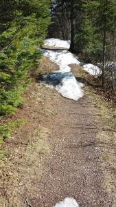
Snow Receding – Areas of the STR race course were starting to loose snow, May 4, 2014

Superior Spring Trail Race
50KM, 25KM & 12.5KM
Lutsen, Minnesota
Saturday May 16, 2020
50KM 7:00AM
25KM 8:00AM
12.5KM 9:00AM

Registration / Lottery:
Opens Wednesday January 1st, 2020 – 12:01AM CST
Closes Wednesday January 15th, 2020 – 11:59PM CST
* Due to high demand, registration for the Superior “Spring” Trail Race is held via a lottery, more details about the lottery can be found HERE

Directions to Race Start:
Caribou Highlands Resort / Lodge
371 Ski Hill Road
Lutsen, MN 55612
Google Maps Directions HERE
Approx Travel Times
1:15 North of Two Harbors, MN
1:45 North of Duluth, MN
4:00 North of Minneapolis, MN

Terrain / Course Description:
The Superior 12.5KM, 25KM and 50KM Trail Races are extremely hilly, rugged and technical out-and-back (100% trail) trail-races which traverses the Sawtooth Mountain Range on the Superior Hiking Trail in the far reaches northern Minnesota .  The course parallels Lake Superior, the greatest freshwater lake in the world, climbs to near 2000′ peaks with breath-taking vistas of the lake and inland forests and crosses whitewater rivers and serene streams while meandering through mystic Boreal forests.  The races start and finish at Caribou Highlands Resort in Lutsen Minnesota.

Superior 50KM
25KM Out & Back Course = 50KM (31MI)
Elevation Gain 4,200 FT
Elevation Loss 4,200 FT
NET Elevation Change 8,400 FT
4 Aid Stations
9 Hour Time Limit
Starts at 7:00AM Saturday
Compete 50KM Info HERE

Superior 25KM
12.5KM Out & Back Course = 25KM (15.1MI)
Elevation Gain 2,300 FT
Elevation Loss 2,300 FT
NET Elevation Change 4,600 FT
1 Aid Station
8 Hour Time Limit
Starts Saturday at 8:00AM
Complete 25KM Info HERE

Superior 12.5KM
12.5KM Point to Point Course. 12.5KM = 7.75MI
Elevation Gain  900 FT
Elevation Loss 1,050 FT
NET Elevation Change 1,950 FT
NO Aid Stations
7 Hour Time Limit
Starts Saturday at 9:00AM
Complete 12.5KM Info HERE

More About the Area:
The North Shore of Lake Superior runs from Duluth, Minnesota at the Southwestern end of the lake, to Thunder Bay and Nipigon, Ontario, Canada, in the North to Sault Ste. Marie, Ontario, in the east. The shore is characterized by alternating rocky cliffs and cobblestone beaches, with rolling hills and ridges covered in boreal forest inland from the lake, through which scenic rivers and waterfalls descend as they flow to Lake Superior. The shoreline between the city of Duluth to the international border at Grand Portage as the North Shore.  Lake Superior is considered the largest freshwater lake in the world by surface area. It is the world’s third-largest freshwater lake by volume and the largest by volume in North America.  The Superior Hiking Trail, also known as the SHT, is a 310-mile long distance hiking single-track hiking trail in Northeastern Minnesota that follows the ridgeline overlooking Lake Superior for most of its length. The trail travels through forests of birch, aspen, pine, fir, and cedar. Hikers and runners enjoy views of boreal forests, the Sawtooth Mountains, babbling brooks, rushing waterfalls, and abundant wildlife. The lowest point on the trail is 602 feet above sea level and the highest point is 1,829 feet above sea level.