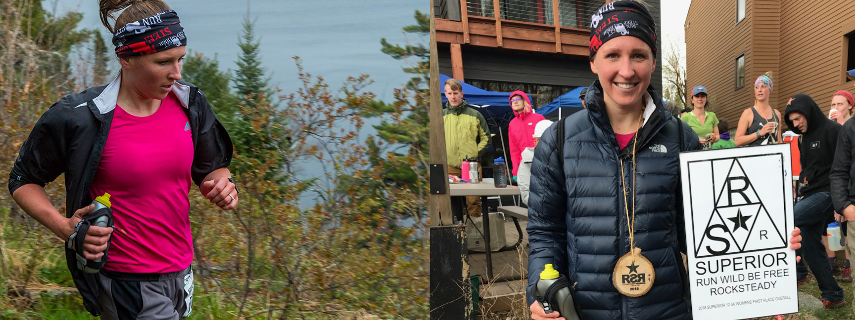
2018 Superior 12.5KM Women’s Champion Bayli Maliszewski – Photo Credit (Left) Mike Wheeler, (Right) Lisa Kapsner-Swift

An Interview With 2018 Superior 12.5KM Women’s Champion Bayli Maliszewski (BM) – Interview conducted by Kevin Langton (KL)


KL: Bayli congrats on your win. That race was incredibly tight with the top three women within four seconds of each other. What were your plans or goals for the race and how did the race play out for you?

BM: I came into the race just wanting to run hard and feel good about my finish. I hoped to finish in the top 5 women but hadn’t imagined I’d finish top female. I was secretly stoked about the weather—50 degrees and rainy is my favorite race weather and it seems to help me perform a little better. This held true for me, as I felt pretty strong the entire race. I was always taught to just look ahead and focus on me and pushing myself to the max, however I think had I looked to see just how close the other two were behind me it would have given me some added motivation to push harder. Lesson learned!

KL: What best prepared you for such a race?

BM: I had trained for a road half marathon which I raced a couple weeks prior, which made this distance very doable. I can’t say I did any speed or specific hill workouts for this race, but had been hitting the trails as much as possible once that dang snow was finally gone! I’m not sure what helped me on the technicality of SHT as we don’t have anything that technical around home. However, I loved how technical the trail is, as it forces my mind to focus on footing rather than fatigue!

KL: What’s something non-running that helped you at Superior?

BM: I had a blast tent camping at a MN State Park with old and new friends the night before, and had so much fun through the entirety of the race focusing on roots, rocks, slippery bridges and awesome scenery. As we all know how mental running is, these positive vibes were a big energy burst for me.

KL: Did you have any low points during the race? If so, what helped you through it?

BM: I actually lost a shoe from getting suctioned in the mud about 5 miles into the race. A guy and I had been leap frogging with each other for the past couple of miles and of course, he passed me when I had to stop and put my shoe back on. Turns out that shoe almost cost me the race! Other than that, I’d have to say I lost a little bit of mental steam on the final straight stretch right out of the woods. I’m not sure that I actually slowed down, but seeing the daunting long road ahead when you’re already tired was a challenge. But I knew I was very close to the finish and pushed my way on.
KL: Bonus question: Please make your own question (and answer) that reveals something you think we should know about.

BM: Do you have any pre-trail race rituals? A beer! (The night before of course…I’m no beer miler.) There’s something about trail running followed by a craft brew. I guess at some point I got the order reversed, but, oh well.

KL: Bayli, thanks again and congrats on another amazing race.

Superior Spring Trail Race
50KM, 25KM & 12.5KM
Lutsen, Minnesota
Saturday May 16, 2020
50KM 7:00AM
25KM 8:00AM
12.5KM 9:00AM

Registration / Lottery:
Opens Wednesday January 1st, 2020 – 12:01AM CST
Closes Wednesday January 15th, 2020 – 11:59PM CST
* Due to high demand, registration for the Superior “Spring” Trail Race is held via a lottery, more details about the lottery can be found HERE

Directions to Race Start:
Caribou Highlands Resort / Lodge
371 Ski Hill Road
Lutsen, MN 55612
Google Maps Directions HERE
Approx Travel Times
1:15 North of Two Harbors, MN
1:45 North of Duluth, MN
4:00 North of Minneapolis, MN

Terrain / Course Description:
The Superior 12.5KM, 25KM and 50KM Trail Races are extremely hilly, rugged and technical out-and-back (100% trail) trail-races which traverses the Sawtooth Mountain Range on the Superior Hiking Trail in the far reaches northern Minnesota .  The course parallels Lake Superior, the greatest freshwater lake in the world, climbs to near 2000′ peaks with breath-taking vistas of the lake and inland forests and crosses whitewater rivers and serene streams while meandering through mystic Boreal forests.  The races start and finish at Caribou Highlands Resort in Lutsen Minnesota.

Superior 50KM
25KM Out & Back Course = 50KM (31MI)
Elevation Gain 4,200 FT
Elevation Loss 4,200 FT
NET Elevation Change 8,400 FT
4 Aid Stations
9 Hour Time Limit
Starts at 7:00AM Saturday
Compete 50KM Info HERE

Superior 25KM
12.5KM Out & Back Course = 25KM (15.1MI)
Elevation Gain 2,300 FT
Elevation Loss 2,300 FT
NET Elevation Change 4,600 FT
1 Aid Station
8 Hour Time Limit
Starts Saturday at 8:00AM
Complete 25KM Info HERE

Superior 12.5KM
12.5KM Point to Point Course. 12.5KM = 7.75MI
Elevation Gain  900 FT
Elevation Loss 1,050 FT
NET Elevation Change 1,950 FT
NO Aid Stations
7 Hour Time Limit
Starts Saturday at 9:00AM
Complete 12.5KM Info HERE

More About the Area:
The North Shore of Lake Superior runs from Duluth, Minnesota at the Southwestern end of the lake, to Thunder Bay and Nipigon, Ontario, Canada, in the North to Sault Ste. Marie, Ontario, in the east. The shore is characterized by alternating rocky cliffs and cobblestone beaches, with rolling hills and ridges covered in boreal forest inland from the lake, through which scenic rivers and waterfalls descend as they flow to Lake Superior. The shoreline between the city of Duluth to the international border at Grand Portage as the North Shore.  Lake Superior is considered the largest freshwater lake in the world by surface area. It is the world’s third-largest freshwater lake by volume and the largest by volume in North America.  The Superior Hiking Trail, also known as the SHT, is a 310-mile long distance hiking single-track hiking trail in Northeastern Minnesota that follows the ridgeline overlooking Lake Superior for most of its length. The trail travels through forests of birch, aspen, pine, fir, and cedar. Hikers and runners enjoy views of boreal forests, the Sawtooth Mountains, babbling brooks, rushing waterfalls, and abundant wildlife. The lowest point on the trail is 602 feet above sea level and the highest point is 1,829 feet above sea level.