Superior Spring Trail Race 25KM & 50KM | May 18th, 2013
50KM 7:00AM | 25KM 9:00AM
Lutsen, Minnesota |
Do not reply to this email, please email questions HERE
You can visit the official Superior Spring Trail Race website HERE
|
 |
Welcome Runners!
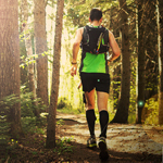
The 2013 Superior ‘Spring’ Trail Races 25KM and 50KM are quickly approaching, are you ready for some quality time on the Superior Hiking Trail? As a testment to the experience, beauty and challenge that this race provides we once again met the field limit in record time – hosting 500 runners from 15 states and 3 Canadian Provinces. If after completely reviewing the information in this email, the information on the Superior Spring Trail Race Website, Blog and Facebook pages, you find you still have questions – please feel to drop us a line (do not reply to this email, please direct all emails HERE and we will do our best to answer your questions). Please note that we head to the race site on the Wednesday prior to the race and our cell and email coverage can be limited at times, so if you have questions, try to ask them before Wednesday if possible! We are looking forward to seeing you all on race day and are looking forward to another successful Superior Spring Trail Race 25KM and 50KM!Sincerely,
John Storkamp – Race Director
& The Entire Superior Spring Trail Race Team |
|

|
|
|
GENERAL RACE INFORMATION:
Everything you need to know regarding the race can be found on our website, use the links below to find complete details about each race distance along with course maps, elevation profiles, directions to the race and more. Should you still have questions after completely reviewing this info., please feel free to contact us!
|
|
|
|
|
|
|
|
COURSE UPDATES:
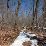
As everyone already knows, a winter of record high snow totals, combined with some extremely late season snowfalls has led to a much later than normal thaw in our state – especially in the northern part where our race is held. Although things have undoubtedly changed in the last week, we were on the trail on Monday May 6th, and our report and photos can be found HERE. Come prepared to run in all conditions including snow, water and mud. We will provide an update on the course on Friday at 7:00 PM at the pre-race briefing so you can make last minute “costume” changes! |
|
|
|
|
|
|
|
RACE NUMBERS AND CHIP TIMING:
Race numbers have been assigned and a list of names with assigned numbers can be found HERE – those that met the deadline will have their name custom printed on their race number. Please know your race number at packet pickup, this will help speed the process and keep lines short. Please use this information for marking your drop bags and share your race number with friends and family so they can track you – if someone asks about “Bill” we may not know, but if someone asks for #125, we will more than likely have some info. Race numbers are assigned in groups and each race bib has a different color scheme – this helps to differentiate runners participating in different distances. Your number must be worn on your front and be visible at all times so other runners and the race organization can identify you – examples of and more information regarding race numbers can be found HERE.We will be using chip timing for this years race – you will be issued a chip on a non-abrasive Velcro bracelet that you must wear on your ankle (either ankle is fine). Be sure to go over any timing mats that are on the ground and never around them.
|
|
|
|
|
|
|
|
OTHER IMPORTANT ITEMS:
- Be familiar with all of the info on the website, it is your responsibility as a runner to know this info.
- Arrive well in advance of the start time of your race – check in closes 1/2 hour prior to the start of each distance. Please know your race number when you check-in.
- Make sure you have what you need. It can be cold – bring warm clothes, it can also be hot – be prepared for all conditions. You will get hungry and thirsty – the aid stations have a lot of stuff, but if there is something special you need or if there is an item that will make or break your race, be sure you have your own stock of it as aid stations can run out of specific food items.
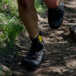
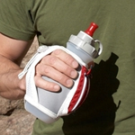
- CARRY A WATER BOTTLE OR HYDRATION PACK – 95% of the experienced runners at this race / on this trail carry a water bottle or hydration pack, there are many reasons for this that by the time you reach the start line of this challenging race you should already understand… carry water.
- Both the 25KM and 50KM are “out-and-back-races. Be considerate of other runners when meeting someone head-on or passing. Be sure to provide encouragement to your fellow runners.
- CUTOFFS: Sawbill 12:00, Oberg 1:30, Finish (Caribou Highlands) 3:00 PM (8:00 for 50KM or 15.5 MM – 4MPH)
- VERY IMPORTANT: If you DNF, you must notify a race official immediately and turn in your timing chip – failure to do so will result in a ban from future races.
|
|
|
|
|
|
|

|
FINAL THOUGHTS:
- We will have posters, beanies, stickers & previous years shirts available for sale at the race – bring some cash and get some really cool stuff! Cash or check only please.
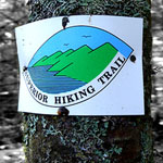
- We are blessed to hold our race on one of the premier long distance hiking trails in the country – our opinion is that anyone who runs on and claims to love this trail should become Superior Hiking Trail Association Members – you can learn more HERE.
- For the first time in our history, we are super excited to announce that the Superior 50KM Ultramarathon will be the 2013 USATF-MN Ultramarathon Championship Race! USATF Minnesota Association members are eligible to compete for $1000.00 in combined prize money and the USATF Minnesota Ultramarathon Champion title for both men and women in both the open and masters division. You can learn more about the USATF Minnesota Ultramarathon Championship HERE.
- VOLUNTEERS – please be sure to thank them, most of them are runners just like you, they are donating their time so you can participate in this race, consider returning the favor at a future race! We are always looking for more volunteers – if you know someone who would like to volunteer for this years race, please send them our way.
- SPONSORS – we have many. Their financial support help to make this race possible, please support our sponsors!
- Post race meal – We will have Chili (self-serve in the mountain-view conference room) for runners only after you finish – please just have one good sized serving so there is plenty for everyone.
- You have trained hard, tapered well and are ready for a great day on the Superior Hiking Trail. We appreciate your continued support – we strive to make the Superior Trail Race one of the premier ultramarathon and trail races in the country – should you have any questions, comments, concerns, complaints or compliments, we welcome them.
- Next years race will be held on Saturday May 17th, 2014
|
|
|

|
The Superior ‘Spring’ Trail Race is a Rocksteady Running Event
Rocksteady Running is operated by ultrarunners for ultrarunners
You can learn more about the Rocksteady Running philosophy HERE.
Run Wild | Be Free | Rocksteady |
|
|